| Kanem Prefecture Préfecture du Kanem | |||||||||||||
|---|---|---|---|---|---|---|---|---|---|---|---|---|---|
| Prefecture of Chad | |||||||||||||
| 1960–1999 | |||||||||||||
 | |||||||||||||
 | |||||||||||||
| Capital | Mao | ||||||||||||
| Area | |||||||||||||
| • Coordinates | 14°07′N 15°18′E / 14.117°N 15.300°E | ||||||||||||
• 1960 | 150,000 km2 (58,000 sq mi) | ||||||||||||
• 1993 | 114,520 km2 (44,220 sq mi) | ||||||||||||
| Population | |||||||||||||
• 1960 | 215133 | ||||||||||||
• 1993 | 279927 | ||||||||||||
| • Type | Prefecture | ||||||||||||
| Historical era | Cold War | ||||||||||||
• Established[1] | 13 February 1960 | ||||||||||||
| 29 October 1962 | |||||||||||||
• Disestablished[1] | 1 September 1999 | ||||||||||||
| Political subdivisions | Sub-prefectures (1993)[2]
| ||||||||||||
| |||||||||||||
| Area and population source:[1] | |||||||||||||
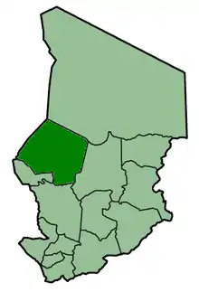
Kanem was one of the 14 prefectures of Chad. Located in the west of the country, Kanem covered an area of 114,520 square kilometers and had a population of 279,927 in 1993. Its capital was Mao.
See also
References
- 1 2 3 4 "Administrative Divisions of Countries: Regions of Chad". www.statoids.com.
- ↑ "Administrative Divisions of Countries: Departments of Chad". www.statoids.com.
| |||
|
Batha · Biltine · Borkou-Ennedi-Tibesti · Chari-Baguirmi · Guéra · Kanem · Lac · Logone Occidental · Logone Oriental · Mayo-Kébbi · Moyen-Chari · Ouaddaï · Salamat · Tandjilé · | |||
|
See also : Regions of Chad - Departments of Chad |
This article is issued from Wikipedia. The text is licensed under Creative Commons - Attribution - Sharealike. Additional terms may apply for the media files.