Roeser
Réiser | |
|---|---|
 Town hall | |
 Coat of arms | |
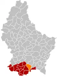 Map of Luxembourg with Roeser highlighted in orange, and the canton in dark red | |
| Coordinates: 49°32′10″N 6°08′45″E / 49.5361°N 6.1458°E | |
| Country | |
| Canton | Esch-sur-Alzette |
| Area | |
| • Total | 23.8 km2 (9.2 sq mi) |
| • Rank | 38th of 102 |
| Highest elevation | 311 m (1,020 ft) |
| • Rank | 97th of 102 |
| Lowest elevation | 256 m (840 ft) |
| • Rank | 60th of 102 |
| Population (2023) | |
| • Total | 6,657 |
| • Rank | 22nd of 102 |
| • Density | 280/km2 (720/sq mi) |
| • Rank | 10th of 102 |
| Time zone | UTC+1 (CET) |
| • Summer (DST) | UTC+2 (CEST) |
| LAU 2 | LU0000211 |
| Website | roeser.lu |
Roeser (Luxembourgish: Réiser [ˈʀəɪzɐ] ⓘ) is a commune and small town in southern Luxembourg. It is part of the canton of Esch-sur-Alzette. As of the February 1, 2011 census, the commune had a population of 5,302.
As of 2005, the town of Roeser, which lies in the north of the commune, has a population of 682. Other towns within the commune include Berchem, Bivange, Crauthem, Kockelscheuer, Livange, and Peppange.
Population
Twin towns — sister cities
References
- ↑ "Population par canton et commune". statistiques.public.lu. Retrieved 11 January 2022.
- ↑ "Alliances". roeser.lu (in French). Roeser. Retrieved 2019-09-08.
External links
 Media related to Roeser at Wikimedia Commons
Places adjacent to Roeser | |
|---|---|
 | ||
This article is issued from Wikipedia. The text is licensed under Creative Commons - Attribution - Sharealike. Additional terms may apply for the media files.